Showing posts with label Hawaii. Show all posts

Saturday, January 1, 2011

The Lihue Sugar Mill


Kauai and the other Hawaiian islands used to be major producers of sugar. There are irrigation canals (like the one we swam at) all over the island to provide water for sugar fields and electricity at several mill sites. The Lihue Sugar Mill on Kauai began, incredibly,  in the mid 1800's, and continued to produce sugar until it was shut down in 2001.


 The following history is from The International Directory of Company Histories, by Gale:

  "In 1849 a German ship captain named Heinrich Hackfeld docked his 156-ton boat Wilhelmine in Hawaii after a 238-day journey from Bremen, Germany. After deciding to become a permanent resident, Hackfeld opened a general store which became very popular with the imported laborers who worked on the islands' isolated plantations. Hackfeld's small venture quickly expanded into other lines of business, including boardinghouses and real estate. Hackfeld later opened a trading house, exporting Hawaii's primary agricultural product, sugar, and importing building materials. Hackfeld's company became one of the largest in Hawaii, operating retail stores and hotels, trading a wider variety of products, and purchasing thousands of acres of property. Several years later Hackfeld died and ownership of the company passed to his family."


This area near the front of the main building looked like a shop.

  "In July 1918, soon after the United States became involved in World War I, the American Alien Property Custodian confiscated H. Hackfeld & Company on the grounds that it was owned by "enemy aliens." All of the company's assets were taken over by a group of competitors, including Castle & Cooke, Alexander & Baldwin, and C. Brewer. The company was incorporated and its name was changed to American Factors (a factor is a commissioned agent), and its chain of B.F. Ehlers retailing outlets was renamed "Liberty House." Under the new management American Factors became more involved in sugar production. Demand for sugar remained high during the Great Depression and World War II, which kept American Factors profitable and allowed it to continue paying dividends to stockholders."

 These things must have had conveyor builts on them originally. There were sugar cane husks lying all over the bottom of the machinery.


  "Although it continued to diversify during the 1950s, American Factors remained primarily involved with the production of sugar. However, in 1959, the same year Hawaii was made a state, airline companies acquired long-range passenger jetliners which made Hawaii suddenly more accessible to the American vacationer. Just as suddenly, demand for hotel space and land began to increase. As a major landowne, American Factors recognized this as an opportunity to exploit its hotel and lodging interests. Many of its existing properties were improved, additional facilities were constructed, and several parcels of undeveloped land were sold to developers at a sizable profit."

On one of the highest floors were large empty foundations of machinery or tanks that had been removed.


You can continue to read the history of the company up the the present day here, but what happened was that due to changing political and economic environments, and debts, the company entered a long decline (for 30 years), and eventually got out of it's sugar production operations. What was of interest to me, was that the company at one point bought a hotel company called Fred Harvey. I used to work for Fred Harvey when they operated the hotels on the rim of the Grand Canyon, so it was a big surprise to find i had a connection to the company that built the Sugar Mills in Kauai.

These looked like boilers to me. There were a lot of electronic panels up here, and this is where the homeless camp was too.


The Mill is impossible to miss any time you drive by Lihue. There is a large conveyor belt covered with impenetrable plants and vines, that goes right over the road. Eventually we couldn't resist and decided to take a look at it one day. It's a huge operation, with the main factory being 5 or 6 stories high, and numerous other buildings nearby.

 The floor was not safe here. In the distance roots from plants were stretching all the way from the roof down to the ground.

Outside was an enclosed open air area that was far more decayed, and overgrown by plants. These may have been an older kind of boiler or oven. Underneath they had fire kilns.

On one of the upper floors we discovered that the factory is occupied by homeless people. We found a camp of sorts with beds, a cooking area, books, even drawings. It was all rather filthy, and the people who occupied it foolishly threw all their garbage down a caged (as in open air) elevator shaft, leaving it to rot and seriously stink up that whole area of the building, right next to where they slept.

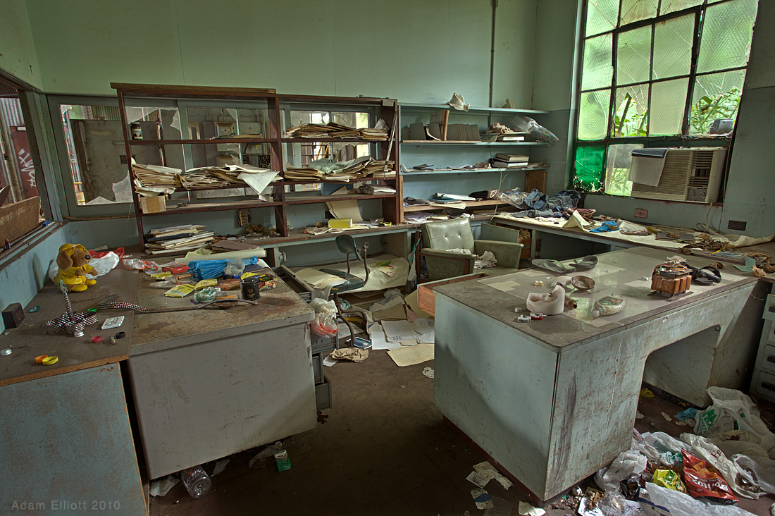
 This office looked like it was very recently occupied.

There were, what looked like child's drawings inside this first aid room.

Maree was sure the homeless people were going to come back and kill us, so she made me stop taking pictures long before we'd seen everything. A few striking things about the interior were that in the "husking and crushing" area there were still husks of sugar cane lying all over the machinery. There was also an interesting sub-floor area that had water flowing through canals in pitch black darkness, in some places making very strange noises. Below are some pictures Maree took.

There were a disturbing number of women's shoes on one floor of the building.

The sub level was very dark. Me in a flash.

The homeless camp.


Some parts were so overgrown they were nearly inaccessible. I can't believe the factory was just shut down in 2001.

Sunday, December 19, 2010

Kauai Hiking


Maui offers virtually no hiking at all, except in the National Park, and there are few trails even there, especially down by the sea. Kauai has lots of trails, and has some of the best scenery in the world to hike through. I had 4 or 5 hikes in mind, but only managed three. One hike was along the Na Pali Coast, one was just a short jaunt to a freshwater jungle swimming hole, and one was a long 11 mile loop hike from the top of the island to the high cliffs along the Na Pali Coast.


Na Pali means "the cliffs" and this part of the island stretches for 15 miles. There the coastline is completely undeveloped. The only trail at the bottom starts at the end of the road on the north side of the island and runs for 11 miles to a place called Kalalau Valley. We began the trail and followed it for two miles to the first beach. Beyond that requires a day use permit. The hike was strenuous, but not as bad as we had heard. Maree had brought big rubber boots and i had worn gaiters, because everyone we talked to said it was one of the muddiest trails they'd ever been on. When we were there it was so dry it was almost dusty, so our extra preparations just made us hot.


Some of the plant scenery along the trail to the first beach.

The big hike i did is called Nu'alolo/Awa-'awapuhi Grand Loop. It starts at the top of the island at the Nu'alolo Trailhead. That trail leads 4 miles to spectacular Lolo Vista, which offers view of the ocean and the adjoining valleys. From there you can take a connector trail, known as the cliff trail, for just over two miles to Awa-'awapuhi Trail, from which you can get back to the road in 3.7 miles. Unfortunately to complete the loop you must walk down the road for 2 more miles.


I had gotten up early to try and make it to Waimea Canyon so i could get some pictures of the sunrise before I started my hike. I forgot that people actually live on the island, and have normal lives, and I got stuck in some morning school traffic in a couple of small towns along the way. I missed sunrise, but a Japanese photographer who had already been there for two hours told me that the sun rise wasn't worth seeing anyway, because it had been so hazy.

 This is a beautiful sandy beach in summer. I've seen pictures of it. In winter strong deadly currents rip all the sand away and store it off shore.

I got some early morning shots and continued up the mountainside to the trailhead, which was difficult to find. There weren't any signs, and the trailhead was questionable. There were several other trails nearby that looked equally legitimate. I wasn't completely sure I had taken the right path for a couple of miles.

The Na Pali Coast. It's all the rain that carves those intricate features.

It's a strenuous hike, and you lose a lot of altitude that has to be made back up at the end.You lose 1,400 feet in the first 4 miles and coming back you gain 2,000 feet. Additionally, the trail is dangerous. The ground is made of wet clay in many places, and I fell down hard twice in the first twenty minutes. I was more careful after that.

When you get to Lolo Vista, you walk out of the forest onto a very high, sparsely vegetated volcanic ridge. The view from the end of the first canyon arm is one of the best valley views i've seen anywhere. You sit out in the open, perched on top of one of those crazy shaped canyon walls, peering down thousands of feet to the jungle canopy and the ocean. It seems incredibly remote, until you hear a rooster in the bottom of the valley where nobody lives. I had to wonder if there was any escape from those things.

The view from Lolo Vista is amazing. From here i took a trail that runs along the side of the cliffs on the right side of the picture (not visible) for two miles,
all the way around the back of the valley.

I hung out for about 45 minutes on the cliff, looking down at helicopters flying in the valley far below me. A huge cloud materialized out of thin air, and instantly filled up a large portion of the valley below. A helicopter down there had to make a high powered, emergency escape over a nearby wall to get out in time. It was an impressive maneuver, and an eye opener as to how fast the conditions could change.

This is what it looks like off the side of the Cliffs Trail. By the time i had to scramble across the landslide i was glad i couldn't see down any more.

I figured i'd better get going, and started on the two mile traverse of the cliffs. Ominous signs said the trail had been washed out and was very dangerous. My guidebook said the same thing. I've been on many trails that claim to be washed out, but most of the time it means the trail is a little eroded, or at most has become narrow in a place or two. In this instance the trail was really washed out. After about a hundred yards the trail disappears at a very bad area. At this point the trail is not on the top, but along the side of the valley wall about 100 feet from the top, and thousands of feet from the bottom. In place of the trail was a loose, muddy rockslide, made up of softball sized rocks. The slide is about 25 feet wide and the other end of the trail starts 10 feet higher than the near side. There is a tremendous amount of exposure.

A weird part of the trail through a dense patch of skinny trees.

It was enough to make me reconsider, especially since I had a new found fear of the wet sloping clay that the good part of the trail was made of. I had become angry about the fog that had rolled in, obscuring the views, but in this case I think it was comforting, keeping me from seeing how far down I would fall if i slipped.


This area was back in the nook of the valley, where a waterfall would normally fall off the cliffs. The fog felt nice and the birds seemed to love it.

The rockslide gave way a little with each step, but I made it across quickly, and that was the only area where the trail was damaged. It's scary, but aside from the vista that two mile stretch was  the most interesting part of the hike, even in the fog.

I took my time on that portion of the trail, saving my energy and hoping the fog would lift, but it didn't, until I was well on my way back to the road. I did the trip in 5 hours, and a group of old hikers from Seattle picked me up on the road and gave me a ride the last mile back to my car. They had done the same hike several times before the trail was damaged, and said that second viewpoint that I couldn't see from the fog wasn't nearly as nice as the first one. So that made me feel better.


Some views out the helicopter of the coastline. The big wall on the left side of the upper picture is the same wall on the right side of this lower picture (blurry because we were flying closely past it). It shows how incredibly thin some of this high cliffs can be.

Flying so low over this stuff was a real thrill.

Sunday, December 5, 2010

Kauai: Stuff To Do

Kauai was much less crowded than Maui, and generally less developed from a tourism standpoint. I liked that about it. Beaches are plentiful all over the island, and they are only crowded around the resort area of Poipu. We spent a lot of our leisure time at sparsely populated beaches on the north end of the island. That meant driving, but the driving is better than on Maui, and the North half of the island is incredibly beautiful. This blog covers some of the activities to do on the island besides lying around on the beach and eating.

 Beaches are all over the place, but there's much more to do on Kauai than walk in the sand.

Kipu Ranch ATV Tour 
 
Maree stands under Mt. Haupu near an area featured in Jurrassic Park.

Our ATV tour was more entertaining than I had imagined it would be. We decided on an outfit called Kipu Ranch Adventures. Our guides were great guys, very friendly and knowledgeable, and funny without being cheesy. They worked hard, kinda, and seemed to enjoy their job. The tour is all within the boundaries of a huge 3,000 acre ranch, and visits numerous Hollywood movie sites. It also offered a view into a hidden, privately owned valley that is not visible from any public roads. It was given by the King of the island to a family of ranchers for a period of seven generations. That time period has nearly expired, and the fate of the valley in uncertain at this point.

From a pass near the top of Mt. Haupu we were able to see the private, hidden valley of Kipu Kai, where they filmed much of Six Days and Seven Nights. 

 On the way back down the mountain, this part was on a thinly paved road.

You can choose to ride a typical ATV or ride one of those two person vehicles. I chose the latter, because i'd never driven an ATV with a steering wheel and wanted to try that out. I had also hoped that maybe Maree could drive some times so i could take pictures, but they only let one person drive, and it was WAY to dusty to pull my camera out while riding. Sometimes visibility was close to zero during the faster moving sections. They warn you to wear clothes that you can throw away and they weren't kidding. The volcanic red dust didn't wash out. I was glad i brought my camera in a waterproof bag.

 This is part of the hill in Indiana Jones and the Lost Ark, where Indy gets chased by natives in the first scene in the movie.


                   Above: After our tour we were pretty filthy.
Left: The tree where Indiana swung from a vine into the water is still there, and now it's a rope swing! More on swimming holes below. 


Our guides told us this is how they season their pigs, with flavored soda. Like chickens, feral pigs are all over the island. With fish, pigs, and chickens running rampant, it would not be easy to survive here.


Hiking and Swimming

The ocean was pretty rough while we were there, as it typically is in winter, so we stuck with land activities for much of the time. Maui offers virtually no hiking at all, except in the National Park, and there are few trails even there, except at 13,000 ft. Kauai has lots of trails, and has some of the best scenery in the world to hike through. I had 4 or 5 hikes in mind, but only managed three. Two hikes were along the Na Pali Coast, but i'll get to those in the next blog post.

Part of the trail along the irrigation ditch. Nearby the ditch goes into a low 800 foot tunnel that you can walk through, bent over, if you desire.

 In the distance is the mountain where the wettest spot on earth is supposed to be. It's normally covered in waterfalls. Our helicopter tour took us back there.

We did another short hike to a freshwater jungle swimming hole. Getting to the trail head in our crappy PT Cruiser was more of a challenge than the actual hike, and i ended up getting a flat tire. I didn't notice the tire until 6 hours later, but still, it's pretty pitiful since the road wasn't what i would consider a bad road.

The swimming hole. There's a concrete damn up there, and the irrigation ditch comes out of the tunnel on the left, then continues to a lock system off to the right. The water was incredibly cold, and a strong current would initially pull you quickly towards the little falls, then spit you out to the side.

The road that the Cruiser couldn't handle. On the way back we picked up a Canadian hiker and gave him a lift back to his car, about 4 miles down the road. He had just finished working on the Olympic preparations in Vancouver, and had decided to get out of town once the  Winter Olympics officially began. He was  a nice guy.

Another option for swimming. On the north end of the island are some large, ominous sea caves. Now after many years of changing tides and currents the caves are inland. Some are dry but this one was filled with deep fresh water. A sign claimed you would die from a cave in if you tried swimming.


Helicopter Touring


The helicopter, tour was a much better value for our money than the one we had on Maui. The helicopter will take you around the entire island, over and through remote canyons, past endless waterfalls, and along the entire Na Pali Coast. It was the most scenic flight tour i've ever been on (other than the Ruth Gorge in the Alaska Range), even though it was raining for much of the tour. This time our helicopter was smaller than the one we had on Maui, and it had doors on it. The windows go all the way down the side, offering great visibility, but as i feared, the reflections on the glass were out of control, even with a polarizer. And I had to bribe someone to get a front seat.

This is an area of immense scale, one of the most sacred sites to Hawaiians, where water gushes out from a huge overhang beneath immense cliffs on the wettest part of the island. It was dark back here.

Turning around from the waterfalls you can see the deep narrow valley we were flying through. This was my favorite part of the air tour. 

We flew up a long steamy looking jungle valley. The rain may have made this portion of the flight more interesting.

 I think this was over the Kipu Ranch area.

The National Botanical Gardens


We weren't originally going to go to the Botanical Gardens on the south side of the island (not the gardens to the North), but on our last day we had to burn up 7 hours after we checked out of our hotel before we could get on our plane. I didn't want to get dirty doing something like hiking or swimming, so we went to the gardens.  I can't say i recommend the place. It's divided into two areas. A "good" area that costs $40 to get into, and a mediocre area, which still costs $20. Additionally you can't just drive up and walk in. There is no parking in the garden, and the 15 minute shuttle ride only goes in and out once every hour. I've been to several other botanical gardens that are of better quality and much cheaper to get into, and compared to the plants you can see everywhere else on the island, it's just not worth the money.


 This was one of the prettier areas.

There's an area of the gardens that you also have to pay extra for for and be driven too, where there is a grove of very large versions of this kind of tree.

Next Time: The Na Pali Coast