For many years i've wanted to go to a place called Blackstone Bay. It is a deep fjord with a large glacier in the back of it, but nobody would take me there. I would hang out at the docks in Whittier and beg ship captains to take me, but they said it was dangerous and full of treacherous ice. OK, maybe i'm making things up about begging random ship captains, but not about the difficulties in getting someone to take me down there. Eventually, after studying maps and satellite imagery i decided that if i really wanted to i could just walk there. Yeah, i “just” had to hike over two mountain passes, across miles of trackless terrain, and up the entire length of a glacier.
On the way up the trail to Portage Pass the weather wasn't looking great. The idea was to walk a few miles to the south (which is towards the right) go all the way up Burns Glacier, then traverse the Whittier Glacier and come over the top of that distant mountain.
Down at Portage Lake. You can see a two story tour boat approaching Portage Glacier on the right edge of the photo.
The summer of '09 had been very good to me and by the end of August I felt like I was ready to try the route. The following is possibly the longest blog i've written, and is unfortunately short of imagery, so I hope I don't bore you, but many people have asked detailed questions about this story, so here is what happened:
Part 1: The Burns Glacier
I drove to Whittier, got started a bit late but I was walking by noon. Although the weather had been great in Anchorage, Whittier had low clouds and high winds. Things didn't look good, but I figured I might as well stick it out until I got to Burns Glacier before I decided on giving up. A few hours later as I arrived at Burns, the clouds magically lifted.
Burns Glacier is in the hanging valley above. It's only 200 feet at most to climb up but there is no trail and the alder trees (virtually every plant you can see) are thick and tangled.
The weather was starting to improve.
Five years ago I had tried to walk up Burns Glacier without really knowing what was at the top. The glacier sits in a vertical walled gorge with cliffs over 1,000 feet high on both sides. It is 3 miles long, and completely lifeless. It's an intimidating place to be, and the first time I walked about a mile up the thing before I kind of freaked out from how crazy and frightening it was, and I turned back around. I vowed to come back one day.
The stream emerges from the ice in 2004. (on Fujifilm Velvia!)
I've had 5 years to try all kinds of stupid things (getting proper training not being one of them) but this time as I climbed out of the alders over the last big rock and the glacier came into view, I stopped dead in my tracks. The glacier had melted tremendously since I last stood before it, five years earlier. It must have melted back over a 100 feet and the entire front face of it had transformed from a vertical wall to a streamlined slope. Whereas before I had to climb up and traverse some sketchy, slippery cliffs over some black gaping holes in the ice, this time I was able to walk on beautifully clean, newly exposed bedrock well past the cliffs and step right on to the ice.


Pristine and previously unknown, beautiful vertically tilted sedimentation has been exposed as the glacier retreats. The yellow line above indicates the approximate position of the BOTTOM of the ice, where the glacier met the cliffs, 5 years ago. At that time i had to climb up to the level area of the wet cliffs on the left and traverse along the side of the glacier until i found an area that i could climb up with crampons and an ice axe. It was challenging and somewhat frightening, as the ice was very steep from the bottom up the sides. The wet cliffs are also covered with clear, slippery algae. More water flows over those cliffs earlier in the season and it had carved a dark cave into side of the ice. Falling in there would have been bad. But hey, i would have only been dead for a few years before my body was exposed to the sun again!

This is what i mean when i said the ice was very steep from the bottom. Again, this is the toe (the front) of the glacier in 2005. This was what it was like at that blue dashed line in the pictures above. That is a stunning amount of ice to melt.
Maybe I really am more experienced now, but after two miles of solo ice travel I still felt pretty collected. I didn't even put on my crampons, and I didn't get bogged down for too long in any crevasse mazes. Then I came to the dreaded Firn Line.
The firn line made me nervous. I'd waited till the end of an unusually warm summer so that I could walk on bare, exposed ice for as long as possible. I can't say that the firn line is something that mountaineers would fear, but for me it meant I had to walk on the unknown, unable to tell for sure if I was on solid ice, or a thin snowbridge barely covering a deep crevasse. The snow in this area was harder than I had expected, but after I thought about it I decided that made sense. It's possible that during our unusually hot summer all of last winter's snow had already melted and what I was walking on was snow that had been compressed from the previous year.

An awesome ice tunnel next to the stream, and the first ice cave i've seen personally that glows with that magical blue light. It was extremely tempting to go in here, and had plenty of room to walk upright (the boulder was nearly 4 feet high), but the whole place was melting like crazy. Two pieces of the ceiling fell down while i was standing at the entrance.
As I got farther up the snow field I could still tell where the crevasses were due to hairline fractures in the snow. Farther still, and I ran into open crevasses, but the nature of the ice up there was different. It seemed fresher and more resistant to the melting heat, with crisp, sharp edges and dry walls visibly covered in something like popcorn frost lower down. Some of these holes were too big to jump across so I had to make my way up or down the length of them until they pinched off.
This is what i was looking at after the glacier leveled out. From here the distant pass is still close to 2.75 miles away, and the glacier here is almost 3/4 of a mile wide.
On a few occasions the crevasses stretched across the entire width of the glacier, and I was forced to find a snow bridge to cross. That was the situation I had been trying hard to avoid, but I had no choice. Once or twice I did find my ice axe breaking through and sinking in up to the hilt as I probed the surface. That caused anxiety and the motivation to move on to test another area.
In addition to the firn line i'd worried about crossing the bergshrund, but in this case it wasn't a problem at all. Finally, I made it off the ice and on to bare rocks. Land Ho! It was a great feeling, after three miles and a couple of hours of nerve wracking exposure to finally sit down and relax.
Off the ice and looking back down the length of Burns Glacier. In the distance you can see where the snow changes from gray to cyan. That is the firn line and from there to the back of the ice (where the nearby pool of water is) is over a mile. It was a lot more snow than i had anticipated having to walk across.
Taking a break by some liquid water I was scanning the last big snowfield I had to go up and noticed what looked like some wreckage. Another ten minutes and I was at a plane crash! The thing had slammed straight into a cliff face and was mercilessly flattened. It was extremely interesting; it's not every day I get to investigate a plane crash.
It had been a float plane and obviously had been on a fishing excursion. Bright colored fishing lures were scattered all over the cliffs along with reels, nets, line, life jackets, a somehow unbroken and sealed glass bottle with water still in it. Other more personal items included rusty finger nail clippers and similar such items. The plane had come painfully close to not crashing, but it was facing the wrong direction entirely, making me think the pilot may have thought he had already crossed over the pass and had turned the plane 90 degrees north with the intention of heading down the bay on the other side. Or maybe it just wrecked and tumbled into that position.

The plane wreckage. They just barely missed the top of the pass.
The engine block and the crushed cabin.
The total flattening of the plane may be due as much to the weight of the snow over the years as it is to the impact.
Artifacts of leisure were all over the rocks, including a rusty nail clipper.
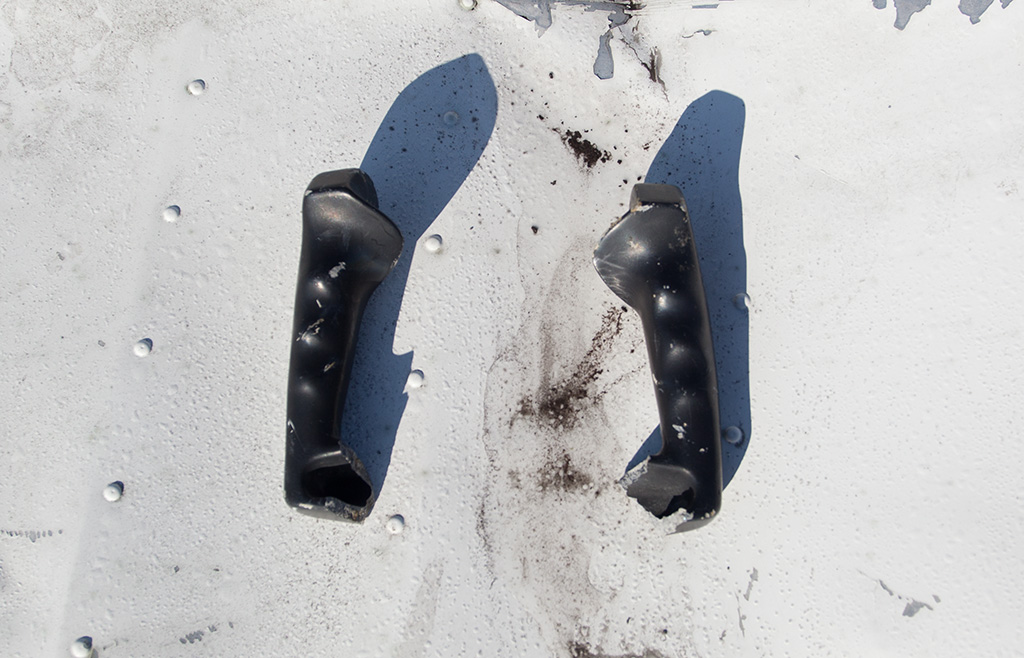
This was the most haunting discover for me. I found the two handles of the yoke not far from each other. They are cast metal, and i imagine the pilot had a death grip on them as the plane slammed into the rock. They were in front of the plane by a wall of rock. It made me wonder if the pilot had been ejected from the plane on impact and into that rock wall? Maybe they had bounced out as they were released from the pilots hands during the impact? Maybe they had been pried out the hands of the body by the recovery crew and tossed over there. I don't know the history of the wreck.
The all-too-expected, cold strong winds drove me away from the wreck sooner than i preferred. I crossed over the pass into Blackstone Bay, my ultimate goal. I found a spot out of the wind and began taking in the incredible view. It was clear that hiking up to this point was worth every bit of the effort. I could see the entirety of the bay with it's scattering of icebergs supplied by Blackstone Glacier.
The view was sooo stupendous I was filled with renewed energy. I decided to climb higher and head farther south in order to get a view of Blackstone Glacier. Looking on maps, I had noticed that if you could make it as far as I just had, you might be able to continue another 4 miles across icefields to the back side and possible approach route for Carpathian Peak, the highest, most impressive mountain in the area. It's entirely unreachable from the east, except possibly in winter.
In another 15 minutes I had made my way far enough around the side of the mountain to bring a hanging glacier into view, and a much better view of the icefields from which it originated. The news was good. The icefields (not pictured) appeared much steeper than they had looked on google earth but just as navigable as what I had already passed through. I wanted to keep going, but I knew I was pushing it as far as time before sunset. It was after 7 p.m. now and I had to get back to Whittier in time to make the last tunnel opening at 10:30. I reluctantly turned around and went back to the pass.
Blackstone Bay in all it's glory! The place i'd been wanting to see for five years. In the foreground milky glacial streams pour out into the ocean. On the far side of the bay (above center) a line of icebergs float away from Blackstone Glacier.
It was late, and looking up at where I was headed wasn't very motivating. Originally I had planned on continuing up from the pass and then either across or above the Whittier Glacier, another 3 miles of travel that would bring me to a point directly above Whittier. From there it should have been a simple matter of bushwhacking downward towards the town.
Looking at the long ascent of snowfields and ledges, and not knowing what I would run into on the Whittier Glacier, I decided I really didn't want to do that. I wasn't sure I had enough time to deal with another glacier crossing and uphill ascent of hundreds of feet. On the other hand, I didn't have any interest in going back down the Burns Glacier either. I was tired of walking across ice and snow, and I was tired of the same old (stunning) scenery along the Burns route that i've seen numerous times.
It was hard to tear my eyes off Blackstone Bay, and on that side of the mountain I found another option. The mountain side up where I was exhibited a kind of subalpine terracing of recent glaciation that I enjoy greatly. One terrace just below me looked ideal for travel and traversed the mountainside for as far as I could see. I thought that if I could take that terrace I might be able skip the entirety of the Whittier Glacier and cross over another pass farther down the valley. I could even see a likely area for a pass to be. As an added bonus, I'd be able to see all new terrain! I decided to go for it.
Travel on the terrace was perfect, so good in fact, that I was able to jog at times, so I was making great time...... until I reached the canyon. There were two canyons, in fact. The first really would just be considered a couloir with a waterfall in it. It was a hairy downclimb on a steep rock face, and even crossing the bottom was a highly undesirable endeavor. The bottom was very steep, with loose, wet, pulverized gravel not quite covering vertical bands of razor sharp, shattered bed rock. Cuts the hands, it does. I navigated over that, but then came an impassable obstacle. A deep gouge in the mountainside with water flowing through it. In winter -- an avalanche chute.
I've been in shallower defiles with the name “canyon” officially attached. This “canyon” was about 80 feet deep, yet invisible on topo maps and satellite imagery. It was too narrow for the resolution. The point at which I first encountered it I could have climbed into it, but not out of it. In the bottom was a rushing stream that disappeared into a webbed snow cave. Sometimes if the snow is thick enough you could risk getting on top and “skiing” down to the bottom. This snow chute was old and full of holes, bridges and cool arches that were as high as 20 feet above the stream underneath, so that was out of the question.

It had taken 6 1/2 hours to get to this point. I had 3 hours to get back. My original plan was to continue up and over the peak on the left, a climb of at least another 400 ft on terraced ledges. For scale, the plane is circled in orange on the far left center. It looks like the letter T.
Looking up wasn't encouraging, so I decided to climb down along the side until I found a break where I could cross. I was descending quickly down cascading mounds and ridges of terraced tundra. I couldn't see where I was going to end up, but i knew the canyon would either end or break open at some point. A few times when it veered 90 degrees to parallel the bay I was sure it was going to end, but each time it turned back vertical.
Two other patterns began to emerge. The cliffs on the opposite side of the canyon were getting higher, and the terraced ridges I was descending on were getting narrower. Before long i'd lost over a 1,000 feet of elevation and the ridge was so narrow I was having to climb down the corner stones of each ridge right on the precipice of the canyon. It came to a point where I realized I wasn't going to get a break until I got faaaar down the mountain. I could tell that because i'd gotten to an area so steep I could see all the way down.
During the whole trip, the next hour or so would be the most frightening and dangerous. I had lost too much altitude to go back up, I thought, so I decided to continue down. The clifftops were overgrown, as I said, in thorny berry bushes or thick alder trees and the only way to see where i was going much of the time was to push my way through these plants, occasionally using them to lean out over the edges so I could scout a way down. Often the branches were my only means of support while i was traversing the ledges or downclimbing. That was not good. Sometimes the situation was so sketchy that I decided it was best to drop my backpack down first. One drop was a little too far, I guess, because part of the metal frame inside my pack cut through the bottom of the bag on impact. It took me at least an hour to get down 400 feet at most, whereas I probably got down the previous 1,000 feet in 20 minutes.
Once i was off the cliffs i knew I'd lost so much time and altitude that i'd never make it out before dark. I only had about an hour of light left, and many miles to go. In fact, I had even farther to go than when I was on the top of the mountain!
I thought it would be great if I didn't have to get stuck in the dark out there (obviously), and while descending i'd been using what appeared to be a boat, anchored out in the bay, as a reference point. The boat didn't look to be very far out in the water, so I thought "hell, i've already come down so far that I may as well go down the rest of the way and see if I can get those guys to take me out of here". I just had to climb down one more cliff, cross a meadow, and then down some more ledges after walking right past a grizzly bear.
The grizzly was quite large, about 80 yards in front of me on the same game trail (bear trail?) I had started following. I yelled at it that I was coming over and then I promptly fell into a hole or something. When I looked back up the bear was gone. I was glad it was gone but fairly unhappy that it's new nearby location was a complete mystery.
The view kept getting better as i hiked towards Blackstone Glacier and it's icefields. The going was easy, and i was led too far while time was running out. In this picture the distance between the prominent peak on the far left and the peak on the far right is six miles. The posterized look of the ice above the main glacier is a pattern resulting from different years of snowfall being exposed through uneven melting.
I had to climb down yet another set of terraced ledges. I was so far down now that there was all kinds of vegetation covering everything. Ferns, alders, cow parsnip, berry bushes, milkweed. I couldn't see anything and kept tripping or slipping on wet rocks. At one point I actually had a major fall off the mountain. I fell head first, but the brush was so thick that I landed on my back on a bed of alder branches. The branches bounced me the rest of the way over and set me back on my feet right below the ledge i'd fallen from! I wish I could travel like that all the time. Twice though, my luck was much worse. On two occasions (I really couldn't believe it the second time) an alder branch snapped back and knocked my glasses off my face. I was blind. It took what seemed like 10 minutes of slow but frantic searching on my hands and knees examining every square inch of the ground under all the brush before I found them. It was already sunset, and the second time I had to get out my headlamp. You might ask why I didn't have an extra pair of glasses, and the truth is.... because I don't wear glasses. I haven't worn glasses in decades but this year I've had some kind of “eye irritation” that has prevented me from wearing contacts. My glasses are my backup for the contacts, and I hadn't ever expected the problem to go on for so long. As a result I don't really have glasses wearing habits or experience. Now I do! Seriously, losing the glasses was the most stressful event of all, along with the cliffs.
Finally I got down into sparse trees on high cliffs, and all the thick brush was replaced with moss. I was in the rain forest. It felt good, except for one thing. There was, once again, no where else to go. Only this time I could not possibly consider climbing down. I was less than 300 feet above the ocean but the rest of the way down was sheer cliffs made of great moss covered monoliths leaning up against one another, tall trees growing where they could. The boat (remember the boat i mentioned a long time ago?) was directly in front of me, but much farther out than it had looked from above. I just couldn't see anyway to get down, and even if I did, I couldn't see a beach anywhere. I looked at the opposite side of the fjord, which I assumed would be similar to the side I was on, and the information was disheartening. I should have looked at it sooner, because that told me right away that i'd never get down. The whole side of the fjord was made up of sheer cliffs that went straight into the ocean. No beaches anywhere in this area. I yelled at the boat for a few minutes and signaled it with a light hoping that if they saw me they could point out a way for me to get down. It became clear that they would NEVER hear me because of all the loud waterfalls coming down the cliff on both sides of me. Kinda depressed, I turned around and started trudging back up mountain.
After another 30 minutes of crawling back over slippery falls and pushing up through endless patches of alders – muddy, back breaking alders – I became so fatigued that I began to slip back down. The sun had set a while ago, the light was fading, and a few stars were appearing. After getting rejected by the same alders that swiped my glasses I had to sit back and admit to myself that I was going to stay where I was, on a ledge, all night long. I'd started at noon. It was 10 p.m..
I was on a broad ledge, probably 15 feet wide, right on the dividing line between brushes and trees. In front of me was steep slope covered mostly in ferns before it ascended into the alders that had pushed me back. Facing uphill, the ledge dipped to the right for a few dozen yards and into some berry bushes before plunging over a small waterfall. The ocean behind me and to my left was mostly hidden by a mix of tall or wind twisted trees covered in hanging lichens. Any farther and the cliffs plummeted. I had to make a camp somewhere in this small area. I figured I could make a fire in the open part of the ledge although I wasn't really interested in fire so much as shelter. On thick mossy ledges under the boughs i could walk and climb a little along the cliffs, and that allowed me to explore a bit into the trees. It was actualy a neat location, and felt secluded (from predators and maybe wind) and I even found a comfortable place to lie down, but it was in a kind of precarious place. I wasn't so worried about rolling off as I was getting up in the dark and not realizing exactly where I was.
A better solution was near the edge of the woods. I found an impossibly comfortable place to lie down right under the trunk of a low lying, twisted tree that stuck out over the edge of the cliff. It was situated in a way that would protect me from rolling off the edge of the cliff, and it made me feel safe from anything sneaking up on me from that direction, like that grizzly bear that was horizontally no more than 1/3 of a mile away. Do grizzlies climb down cliffs in the dark? Your guess is as good as mine, and so would be your peace of mind.
I scrounged some wood for a fire and a shelter. I had a lighter and a headlamp, but I didn't bring a knife, so I was unable to cut needle covered branches for insulation, or dead branches for fire. Instead I pulled up a whole bunch of ferns and piled them over the few branches i found on the ground. It was a pitiful shelter. I should have spent more time on that than time spent gathering wood for a fire because I found out everything was far to wet to light up. Only the thinnest twigs would catch fire, and only stubbornly. It didn't matter anyway. It was already after 10:30 pm and I was too tired to care. I crawed into my shelter to sleep.
I have slept outside without a tent before, but never in Alaska, and never with just the clothes on my back. It was a cold night. I had brought enough clothing to deal with any kind of conditions on the glacier, so I put them all on. Originally I was using a rain jacket as a membrane between me and the ground, but after a while I started using it as a blanket instead. The moss worked well enough as insulation. The other problem was my feet. I initially left them in my boots but they were sweaty and after a couple of hours were quite cold, as were my legs, which were sticking out of the shelter. I took the shoes off and shoved both feet into a cut off jeans pantleg that I use to store my crampons. That helped. I also took everything out of my backpack, which is extra long, and put my exposed legs inside the bag, zipping it up around the sides. That helped immensely. Even with the improvements though, there was always a weak spot somewhere in the system, and after what would seem like only 20 minutes i'd get cold enough to shiver. It became very frustrating after a while, but usually just the effort of moving around to readjust things under the cramped shelter would generate enough heat to keep me warm for another 10 minutes. Then i would get cold again for 10 minutes.
It was a long night where sleep occurred without me noticing. Strangely I wasn't ever scared about anything, nervous from time to time, sure, but not any more nervous than I always am when sleeping outside in bear country. On some level I actually thought it was pretty cool. I felt simply like another animal living outside. But i also felt very poorly evolved. To think i was a species that has difficulty surviving the period of the day when the planet is facing away from the sun, it seemed ridiculous. I felt about as advanced as a reptile. So it was, lying on the surface under the stars waiting for the sun to come back around so my poorly evolved eyes could get me moving onward again.
The night was more about waiting than sleeping. After a long time i was sick of being cold and i noticed the sky got lighter. It was 6:30 a.m.. I took a groggy century to eat my last flattened, soggy peanut butter and jelly sandwich. There was nothing to do but start off the day by climbing up a slick muddy slope covered in thick alder bushes. That notion made me take even longer to eat the sucky sandwich. After the first cliff would be another, then another one, then another one.... Lame....
I decided to put my crampons on. I was a little concerned they might trip me up or get tangled in branches but they actually worked incredibly well! My ice axe dug into the soft ground so well I sometimes had to work it to get it back out. That was a great idea, and saved me a huge amount of energy (and considerable time) getting back up the slopes to the main broad terrace where i'd seen the bear. I would never have thought of using ice climbing gear on anything other than ice!
The day went well for another 30 minutes before things started going downhill. Just at the top of slopes I stepped into a stream, which was OK, i'd been doing that a lot, but the second step was into water deep enough to go over the top of my boots, soaking my feet.
A picture of my crappy shelter that morning. You can see how the cliff drops away where my head would have been under the plants. As the night wore on the ferns wilted, contracting so they dropped between the branches and tickled my face. This day i put the camera on full automatic, and the results show the terrible auto focusing choices of an expensive camera.
I wasn't feeling very energetic that day, but the glazed sky motivated me to get moving. Western Prince William Sound is famous for it's bad weather. The last few of days of sunshine were a fluke. I knew what the weather was normally like. I wasn't exactly lucky to have another day of decent weather, I had purposely tried to do the hike in the middle of a pressure system, but I knew the system was passing by, and sooner rather than later the weather would go bad. Very bad. I was determined not to spend another night out. The way I looked at it, I had approximately 15 hours to achieve that goal.
The meadows I had been looking forward a day before to were a serious disapointment. They were covered in attractive low lying plants that completely obscured the jumble of rocks and mudholes underneath them. I had to cross numerousl deep streams that involved getting the inside of my shoes wet. With soaked feet I had to take my boots off once an hour and wring out my socks. There weren't any game trails to follow. In between the meadows were long stretches of thorny berry patches and high grasses. Night had produced a heavy dew, and before long I was soaked all the way from my waist down to my toes.
After two miles i came to a wide side valley, and another bear. This time it was the biggest black bear i'd ever seen. It was on top of a steep bank, sitting down like a teddy bear eating berries. It looked genuinely happy, minding it's own business on a sunny day. I announced my intentions. The bear stopped eating and stared at me with a cocked head, like I had just stepped out of a spaceship. It must have stared at me like that for 20 seconds before it charged off behind a hill. A few minutes later it came out from behind the hill and ran across the valley at full speed, apparently still terrified. That was nice and easy. I wondered if it had ever seen a human before.
At another point a small plane came flying right overhead, low to the ground. I was wondering if people might be searching for me, and i had to admit that i didn't know what was going to happen later in the day. I took off my bright orange jacket and started waiving it in the air to signal the pilot. They either weren't looking for me, or they didn't see me. It made me realize that it was up to me to get out of there. Searches for people often take up to 3 days, and i certainly wasn't planning on waiting that long.
After several hours I made it up to a high point and had to make a decision. It was about 11am. I knew Whittier was on the other side of the mountain. I could climb up the mountain and see what it was like on the other side, and hopefully make a phone call for help if I couldn't go farther. The weather looked like it was actually improving instead of getting worse, so chances were good that i'd be ok for a while on the top. Getting up would be difficult and use a lot of energy, and I didn't know if i'd be able to get down the other side or not.
The yellow line shows my initial high route that i had intended on following the first day. It worked well for the area visible in the photo. The green line shows my path the next morning, the most distant dots are in Shotgun Cove.
A google earth overview of my entire route. The red dotted line is my original planned route from Burns Pass back to Whittier. North is to the right.
My other choice was to go down. I was on a low pass overlooking a bay I recognized as Shotgun Cove. It looked like there was a boat in the middle of it, and I could see it's famous shipwreck just off shore near the distant mouth of the bay. Closer to me I could see miles of exposed pebble beach that would make for some very easy walking, but going that direction wouldn't get me any closer to Whittier.
I decided to go down, not up. I could see in that direction. I could see a boat, and I knew that the shipwreck attracted gawkers. It was almost noon on a Friday, and it looked like another nice day in Prince William Sound. People would leave work early, drive down to Whittier, and maybe get out on the water by 4 p.m. if they owned a boat. Shotgun Cove is the closest place for people to go and anchor for the night. Even If I had to spend another night out I felt sure that someone would come by to see the shipwreck before the weekend was over. I just had to get to the wreck and I could wait.
All morning (and through the night) i'd been listening to the glacier calving off icebergs. Just before i stepped off the pass i heard one very loud boom, like thunder. I thought "wow, that must have been a big one," and i bid farewell to Blackstone Bay.
It was an easy descent from the pass to the ocean.
The long leaf plants in the background were a new species for me. They seemed like something you'd see in the tropics. Kinda looked like they'd be good in a salad.
Throughout the morning I had been forcing my way through patches of thorny berry bushes between marshy meadows. I was getting very scratched up on my arms, but I was also eating lots of berries. The berries were fantastic, perfectly ripe and bursting with juice. They supplied constant energy so I ate them in handfuls. Going down into the forest now, I ran into some additional varieties. Huckleberry and some orange berries that tasted mostly like water. It was great not to have to worry about food.
Finally having a known location where I would stop walking, I began with my other task, making sure that I was more comfortable in the event that I had to spend a nother night out. I began gathering extra berries into a sandwich bag. I also gathered lots of the spanish moss type of lichens hanging from the trees and compressed it into my pack. I'd seen survivorman use that stuff effectively for fire starter.

The best berries i've ever had. Notice how the auto setting of my camera decided the plants on the left side of the picture were the best area to focus on.
I stumbled out into a salt water marsh. A minute later I was on the beach! The only problem was that while I was in the woods I had inadvertently walked out to the end of this long finger of land and i was on the wrong side of the water in between. I had to backtrack for 15 minutes to get to the other side. That was the worst example, but the situation kept repeating itself. The tide came in after only about 1/2 an hour of pleasant walking, so I was forced off the beach back up into even thicker patches of brush than I had to deal with earlier in the morning. I couldn't find a place to climb off the beach before i had to step into sea water up to my knee. Freshwater, marshwater, seawater, my boots were going to smell really good later.
Up and down, up around and down, I always had my eye on the shipwreck when I could see it. I found out that climbing higher into the woods, away from the beach, often would open up into long marshy meadows that were easier than shoving through the woods. Along the way I found a big black trash bag tangled around the roots of a large piece of driftwood, and some nylon cord tied around a tree nearby. I took that stuff. I took note of kelp on the rocks when the tide was out. Although food was plentiful i did notice that the water down at sea level didn't taste very good anymore. Going through those low altitude marshes ruined the flavor.
I came out of the woods onto this salt water marsh. A welcome sight! I thought i was home free at this point, but it still took at least two more hours of trudging through brush and undergrowth to get to the shipwreck.
Finally, at 2 p.m. I made it to the shipwreck. Coming down out of the woods I heard voices. I ran down, exploding out of the brush onto the beach. There were two kayakers pushing offshore, and when I yelled at them as I burst out of the woods I gave them a good scare. They stared at me like I was dressed in Conquistadore armor. Maybe it was my muddy, berry-stained pants, my muddy and berry-stained shirt, or my muddy and berry-stained shoes that had water squirting out of them as I walked, or the dozens of bleeding wounds all over my arms. I explained the situation, noting that people were probably looking for me, and asked them if they could go back to Whittier and get me some help.
Incredibly, they were reluctant to offer help! They didn't feel like going back to Whitier because they were just beginning a 4 day kayaking trip. They did inform me that there was some intermittent cell phone reception at this area. I tried it out, and it worked well enough. They gave me the name of their outfitter, and calling those people i was able to get connected to a water taxi service. Water taxi services charge a set fee for use of the boat. So if you have 6 people it's not a bad deal. Since it was just me it was going to cost over $300, but that seemed worthwhile considering the other options.
This is the weird looking shipwreck. I didn't move from this spot until the taxi came. I just took off my boots and socks, listened to the water quietly lapping the shore, and watched the sun dance across the bottom as tide continued to come it.
My mission for the day was over and i still had 7 hours of daylight left. I had 45 minutes to relax quietly on the beach. When the water taxi arrived the captain took out a map, and was impressed with my little trip. That day it had taken me 7.5 hours to go 8 miles. The speedy water taxi took less than 10 minutes to get to Whittier.
I had spoken to Maree on the phone. She was a nervous wreck (to put it mildly), and had the Coast Guard and Air Guard looking for me, but they were all looking around the Burns Glacier and Portage Pass, up to 9 miles away from the shipwreck. She'd gone to Whittier early in the morning and her mother, who is in the auxilary coast guard, went down there too. When the taxi arrived in Whittier Maree met me and took me over to her parents boat, where i was surprised to see two of my friends waiting for me. I was genuinely impressed that they would leave work out of concern for my well being. I felt kinda bad about the whole thing. Maree's mother kept trying to feed me and get me hydrated. Although i had a three pound bag of berries as proof, no one really seemed to believe me when i said i wasn't too hungry, or when i mentioned that a mountain rainforest offers plenty of drinking water.
My arms have never been this scratched up. And after this i took the most painful soapy shower i've ever had. My legs were similar even through pants. Even my midsection had numerous scratches and bruises. My feet were totally raw, in fact, while most of the scratches barely hurt at all after 24 hours, my feet hurt for days.
To everyones surprise, after not too long i said i had to go to work. It was true! Part of my motivation had been to fulfull my responsibilities at my job. I run a little business, and on Friday afternoons i have to go pick up the weeks work and give it to my employees. If i missed the window for that i'd lose thousands of dollars, and have some explaining to do. I made it to town just in time, i didn't have time to go home or anything, and my employees were horrified at my condition when i showed up to give them their work.
I'd wondered if i would make it on the news that day. Silly me, i'm just one of thousands of idiots out in Prince William Sound every weekend. My ordeal was eclipsed by a group of kayakers. That day they had paddled up to Blackstone Glacier. Three of them climbed out onto some rock ledges on the side of the fjord to take some pictures, while a 4th held onto the kayaks. At that moment the glacier calved a huge iceberg, causing a massive wave that ripped the kayaks away from the guy holding the ropes. I'm betting it was that last big boom i heard on the pass that day. The kayakers were stranded on a rock ledge, unable to go anywhere. They were barefoot, and they sat there huddled together for two nights before a tour boat spotted them. By that point in time a couple of them were incoherent.
I made a bad decision. But i got myself out of it the next day. It was quite an ordeal, one of the most fatiguing experiences i've ever had. In may ways i'm glad it happened. It certainly made me more interested in survival knowledge. Now that i know what i'm capable of doing, i've become more interested in off trail wilderness hiking as well as being more aware of the difficulties involved in that kind activity.
The day i had to hike out had a significant mental impact on me. In a weird way it was very liberating to have my entire existence stripped down to a single purpose. There was nothing to worry about at all, there was only what was, and a man moving through it. There was no complaining to do, just a single goal to achieve, regardless of what obstacles were in the way. For four days afterward i was in a very peaceful zen state of mind. I had hoped to hang on to that state of mind for longer, but it faded away after days of modern living.


 One of the boats in the fishing fleet was the Kodiak, (a boat featured in the TV show Deadliest Catch.) If you think all these crab captains just go home for the rest of the year and sit around once the season is over, you're dead wrong.
 Purely by chance, the Captain Bill Wichrowski happened to be on deck (behind the red bearded guy). As you can see, he looks exactly the same as on TV. He's even wearing the same clothes!