Showing posts with label Vacation. Show all posts

Sunday, February 27, 2011

Pictures of Picture Takers

During the summer of 2010 I had three sets of summer visitors back to back. Unfortunately the weather was far from ideal during much of that time. Below are pictures of some of the things we did.

My friend Jeff came up first and was here in Alaska for Summer Solstice, the best day of the year. The weather was pretty bad most of the time Jeff was here (I think it was the first time ever that it rained here on the solstice), but that was ok, because he used to live here, so he wasn't seeing things for the first time, and we were inebriated most of the time anyway.

 I took Jeff up to Black Lake. A pretty nice hike for a 12 minute drive from home.

From there we headed down to Williwaw Lakes, and took the looonnggg way around the front of O'Malley back to Glen Alps. That trail, by the way, is a stunning example of poor trail design.

 After a lucky break of fantastic weather in Seward, i took Jeff to Exit Glacier, on the edge of Kenai Fjords National Park. In this picture all the forest in the foreground is brand new, advancing towards us as the glacier retreats behind us.

The short excursion to Exit Glacier offered me a very fun new thing to try out. I've been to Exit several times, it's one of the only things most people get to see in the park, and it's a very easy, paved walk up to the glacier. Along the way is a spur trail, that takes you along a very strenuous hike up to the ice fields. You can read my post on the Harding Ice Fields for more information.

At Exit glacier are a million signs warning you not to go any farther. These signs are around for good reason. On the other hand, it always irritates me because Exit Glacier has divided, at the bottom, into two toes. Each toe currently occupies a rough rocky ravine. This has only developed in the last 10 years, as far as i know, you  used to be able to walk up to the toe at ground level, on the gravel benches by the river.

I noticed that at this time most of the river is coming from the far toe, invisible from the official trail. So i decided we should go and see what was over there. I wondered if there would be an ice cave. Through a bit of work we found a way to clamber over the bottom of the glacier and it's cliffs, and do a bit of tricky hopping around to avoid stepping in any water. What we found was worth the effort.

Here you can see the deep narrow gorge and the glacier high above in the distance. This gorge was present even when it and everything else in the picture was under ice, as recently as a decade ago.

The river we walked along emerged violently and suddenly from a roaring gorge. There was no way to enter the gorge, so we had to backtrack and climb up the backside of the cliffs. That in itself was a little sketchy, and as Jeff pointed out quite accurately, it was similar to caving, but without a roof over our heads.  From our perch on the cliff we could see up the gorge to the glacier, still a ways off. We tried to push on but the terrain was too dangerous and seemed to get worse as we went on. I was satisfied.

Lying on my belly, i was able to edge over the side of the sloping cliff for this wide angle straight down view of a violent waterfall in the gorge. It was very loud here.

Jimmy at Portage Glacier.

The day after Jeff left Jimmy arrived. Jimmy was only here for 4 days, so we were pretty busy trying to make the best of it. Except for the first day, Jimmy ended up being pretty lucky with the weather. I was able to get us out away from the clouds into nice areas.

 I have a book showing everthing from here to those cliffs on the right, all under about 200 feet of ice in the 1980's.

 A beautiful day above Whittier. One of those times when it was cloudy in Anchorage all day.
 
 Jimmy at the Matanuska Glacier. His first time on a glacier, first time in crampons, first time with an ice axe.

Some really cool seracs. At least this post has pictures with people for scale.

Every time i go toe the Matanuska Glacier it looks totally different. The last time i visited i was sure the lake at the glacier was almost gone. This time it was bigger than i've ever seen it.

 This was as far as we got before we had to turn around due to time limits. Jimmy did not want to turn back.

After Jimmy left my sister, who has never visited me, and her boyfriend Danielle (whom i had never met) came up at the beginning of August. Danielle is an Italian working and going to school in the United States. Neither of them had been anywhere close to Alaska. I can't even remember how long they were here, and i think they got the worst of the weather. Still, we were able to do things and had some good sun now and then.

Mary Beth and Danielle at Gold Cord Lake.

 Fisher came along, got wet, and started shedding in the heat, the room temperature heat.

Fisher got so hot he had to seek solace in the inadequate shade of fireweed.

 Fisher on the way back to the mine. Looks like Fisher is hijacking this blog, so i'm calling it quits for now.

Saturday, February 12, 2011

Zebra Slot Canyon


A few years ago, i was browsing Google Earth, looking at remote areas in the desert that were well away from roads and trails, just to see what was there. I came across some some interesting sand dunes in the Escalante area that i had never heard of. Open fields of dunes are somewhat rare in the American Southwest, and these appeared large enough from space that i was intrigued. The problem was they were miles away from the nearest road, and getting to them would be a cross country trek across very hot terrain.

Since my Blackstone Bay experience i've become more interested in cross country hiking. Last year, revisiting the sand dunes in Earth, a few photos had been added to the area, revealing that the sand dunes were indeed large and interesting. Additionally i found the location of two noteworthy slot canyons very close by. I had heard rumors of, and occasionally seen a photo of Zebra and Tunnel slot canyons, but i never knew where they were. It turns out they are both within a mile of each other and some distance to the south of the big dunes.

 
The normal way to get to Zebra Slot is to hike in from the Hole in the Wall Road, over 3 miles away, and return via the same route. I don't like backtracking, and if i wanted to see Tunnel Slot and the Dunes that would add on miles of backtracking. I thought it would be fun to design a loop hike using sattelite imagery.  I found a less used sand road to the east that would make a great starting point for the loop, incorporating all three destinations and offering a look at bare rock wildlands in between. The total hike would be between 10 and 12 miles, depending on how far along the dunes i wanted to go.

The route that i actually ended up hiking. The black line is one mile long.

A closer view of the "wildlands" that i traversed on the way from the Start to the Dunes and Tunnel.  The beige patches are old sand dunes that are generally stabilized with plants. I tried to stay in the white bare rock areas, which was sometimes not easy because the horizon was often obscured in the sand. The large green plants are Juniper trees. The smaller speckles are mostly Sagebrush.  


When i first got to the rocks i followed a long drainage with larger and larger waterholes. Some were dry, some were wet.

Starting at one of the ends of the Spencer Flats road i made the three mile walk to Tunnel Slot.  I'm still bad about bringing maps with me, so i was using my iphone as a gps from time to time. I highly recommend NOT doing that, as the iphone (at least the iphone3) is a terrible navigational aid. You have to be moving for it pinpoint your position and show your direction. As soon as you stop moving it looses your direction. So if you are walking off trail, through endless small obstacles, you can only glance at the screen for a second or two to get your bearings. It also uses immense amounts of battery power.

It was a cold, windy morning (it had been 25F that night) but I made it to Tunnel Slot without any major problems. In fact, i was hugely surprised that i navigated so accurately across the terrain. I came right up to the back of the Tunnel, which was nice because the front of the Tunnel was flooded, so i didn't have to feel disappointment in not knowing where the tunnel went.

Acres and acres of open bare rock. I love it. In the foreground are what they call Moki Marbles. They are iron rich mineral deposits, some of them perfect spheres. In some areas there were so many of them that you literally had to watch your step.

The beginning of the Tunnel Slot wash is fairly unappealing and somewhat choked with dead willow bushes. If i hadn't just walked back along the top i would never assume this led anywhere of interest.

The canyon opens up briefly and then squeezes shut abruptly. You can see the tomb like entrance to the tunnel up ahead.

The tunnel looked about 60 feet long and was full of water. The water at the entrance looked more than 3 feet deep, and was hard to avoid unless you ran along the wall bouncing back and forth Prince of Persia style.

From the front of Tunnel Slot to the front of Zebra Slot is 1.5 miles. This was the only part of the hike where there was any semblance of a trail. The trail was largely just the sandy riverbed, so there may as well have been no trail at all.

Looking back down the "trail" between Tunnel and Zebra slots.

During this time i came across two pairs of people. The first pair was an older couple with a dog who didn't seem like they had the strength to make it all the way to Tunnel Slot. I am sure they perished. The second pair of people were a couple from Amsterdam, and the guy was a photographer. They unfortunately arrived at Zebra Slot exactly as i was getting ready to enter it. They were very pleasant, and being a photographer, he was patient about waiting while i went up ahead. The slot was far too narrow for more than one or two people to be in it. In fact, there are only a couple of spots where two people might be able to get around each other.

A mile and a half later i was approaching the outlet of Zebra Slot up ahead.
Wait, is that a bit of blue sky?

I  spent about 40 minutes around Zebra Slot, and then continued on to see if i could make it to the dunes. The rock landscape was getting more interesting as i followed the wash north of Zebra Slot, but it also was getting more confusing. I followed the sand for over two miles before i came upon the large dunes. Along the way i passed a fantastic oasis, with two trees growing out of wet sand, and a small pool at the base of a slide.

Zebra Slot Canyon. On the right you can see some of those Moki Marbles embedded in the wall.

The canyon continues for a while and then ends at a dirty pool and dry waterfall.  

Looking up. Zebra Slot gets it's name from the stripes in the walls.

The sun had come out and the wind died down. The temperature on the rocks skyrocketed until i wanted to take off my shirt. Amazing, considering i started out wearing a coat and gloves. The area must be an inferno in the middle of summer. After i got hot i had to do some steep climbing and i ended up dizzy enough that i had to take a break, realizing for sure that i was sick with a cold. I'd been denying it until that point.

 Above the oasis i came upon this landscape of fantastic smooth white rock withe red stripes and pink hues. It the bright sun it was almost to much to bear.

It wasn't much longer before i reached the dunes. I had planned on walking along to their northern end, but i was tired and low on water, so i headed back. I made my way 3 miles across stabilized dunes and patches of bare rock, and i erred on the side of caution, coming back onto the sand road about 1/4 mile from the truck, which was at the end of the road. I didn't want to miss the end of the road.

This was a crucial decision point that i hadn't planned on having to make. Looking at the imagery i knew that i would encounter a pyramid shaped mesa and that i would need to walk to the left of it to get to the sand dunes. I never expected to walk up to TWO pyramid shaped mesas that were a near mirror image of each other! By this point i was getting tired, so choosing the wrong path would probably have used up the rest of my recreational willpower reserves. This was where i had to choose because the watershed divided, forking off toward each distant monument. I chose correctly.

Finally, the Big Dunes! I was too tired to bother climbing up them. Once again i've taken a picture with nothing for scale. The top of the cliffs over there is 300 feet higher than the rock i was on, and i still had at least three miles of walking through sand to get back to the truck.

On the way back i'd only driven about a mile before i came across a compact Chevy sedan, bottomed out and abandoned in the middle of the road. I couldn't believe someone would even attempt take that car all the way out here, so i got out to take pictures of it. While i was taking pictures the driver of the car came walking down the road. He was a German tourist (actually a teacher on a sort of exchange program) and he wanted to know if i could help him.

Of course i helped him. He was about 11 miles from the nearest paved road and it was close to sunset. Although i was impressed with how far he got the car before it became stuck i berated him for being foolish enough to try it. I just walked 10 miles and i was hungry, sick and dirty. I didn't want to do anything but take a shower and get some dinner before the restaurants closed in Escalante.

First i just offered him a ride back to town where he could get a tow or buy a tow line. I told him i'd come back tomorrow with him if he needed me to. He was freaking out because he claimed he had to catch a plane the next afternoon (the next day i doubted this was true because i saw him walking into the Capital Reef visitor center at the same time he said he had to be on the plane).

ATTENTION TOURISTS: NOT THE RIGHT CAR FOR THE JOB.

So we tried to dig his car out for a while, which was hopeless. I told him i'd seen a large camp halfway up the road, and that those guys might have a tow rope. The camp was still there and the guys camping were making dinner. We had arrived at exactly the wrong time, but one of them was generous enough to put aside his dinner, get on his ATV, and follow us back. He had a winch but for some reason he thought the best thing to do was try and tow the car even farther down the road to this turn out area. The sand was deeper down there so i couldn't understand why he thought that was the thing to do. He was being very generous with his time though, so i was patient while he failed.

I finally convinced him to try and tow the car backwards to the point where the surface was more firm. The car was so well beached that the ATV just kept towing itself back to the car, instead of vice versa. So we had to dig it out some more (we found out the wheels weren't really touching the ground), and nearly burned up the engine of the car before we finally got it moving toward safety. All in all it took and hour and a half for me to help that guy with his car. He was certainly excited to be free from his predicament.

Saturday, January 29, 2011

Broken Camera

Last spring i went back to Utah for some more exploring. This time around my area of concentration was going to be the more remote areas of Capital Reef National Park, since i've been to most of the easy to get to places. I also wanted to take a look around the Escalante River, possibly driving down the Hole in the Wall Road.

I rented a Jeep, but they didn't have it upon my arrival in Grand Junction, so they gave me a new, full size Silverado instead. I didn't want something that big, but the truck was a comfy ride and had a lot of power. It worked great in the sand.

The second bit of news for me was that on the day i arrived there was a freak blizzard. The whole region was getting pounded by snow and high winds, and the temperature plummeted 30 degrees overnight. Power was out in several of the small towns where i  planned on staying.

I decided to stick around in Grand Junction for a day or two, and visit Colorado National Monument, a little park i'd always ignored (pictured at left). This turned out to be a blessing, because not only is the park worth visiting, but i found out when i stopped for my first hike, that the brand new hiking shoes i had purchased for the trip turned out to be two left-foot shoes. I hadn't tried them on since i left the original store.

The good part was that they had the same store in Grand Junction, and i  was able to exchange them for a proper pair of shoes the next morning.


 The horse preserve. There's a nearby coal mine too.

I had never been on the interstate through south central Utah. It had some nice scenery too. Here the interstate cuts through the San Rafael Swell.

Afterwards i tried visiting a Wildlife Preserve outside Grand Junction with wild horses living in it. I thought if i was lucky enough to see wild horses, they might look pretty cool in the snow. The road though, was made of that super slippery grey clay that makes up the Book Cliffs. The road was very icy, and where it was melted it actually felt more dangerous than the ice. I was only able to get down the road a few miles before i came to a locked gate. Apparently that road becomes impassable in snowy weather.

 A view from Boulder Mountain across Capital Reef to the Henry Mountains (the last mountains in the contiguous U.S. to be put on the map. The video features the mountains from a similar distance on the other side.

My 8 days in Utah were cursed by continuing bad weather. High winds and temps in the 20's created frigid wind chills, and large sandstorms. A few days i devoted to sightseeing from the vehicle. I went on a 60 mile dirt road through capital reef, checked out some roads near the Henry Mountains, Dirty Devil River, and White Canyon, saw some interesting ruins, and revisited the Needles District of Canyonlands for two days. The Needles did not fail to impress, once again.

Down a selectively chosen dirt road near Escalante i came across a promising hiking area.

The farther i walked the more the place molded itself into my favorite type of terrain. It was close to sunset though, and i had to get a hotel room, so i decided to come back later.

Two days later i stopped by in the morning. I walked considerably farther, until i got to this place. There was a way down, but by this time i was sick with a cold, and i could tell that i really should enjoy the hike down this canyon later in the spring, or summer, or fall.

Unfortunately i don't have any pictures of most of those activities, because my camera broke on that 60 mile road trip through Capital Reef. The camera bounced off the armrest in the truck and hit the carpeted flooring. It was only a two foot drop at most, but it must have hit at just the right angle, and at the moment that the truck was bouncing back upwards. It would no longer take pictures, and it was the morning of the 4th day of the trip!

 The last photo i took before the camera broke. It broke somewhere in view up the road.

It would, strangely, take video without any problems. The problem was with the shutter. So i have put together a video of some of the places i visited during that time. The locations are places i visited with the truck. I decided that since it was broken there was no reason to carry it along while i went hiking (and i noticed the difference in my backpack).


Spring Roadtrip 2010 from Adam Elliott on Vimeo.

Saturday, January 1, 2011

The Lihue Sugar Mill


Kauai and the other Hawaiian islands used to be major producers of sugar. There are irrigation canals (like the one we swam at) all over the island to provide water for sugar fields and electricity at several mill sites. The Lihue Sugar Mill on Kauai began, incredibly,  in the mid 1800's, and continued to produce sugar until it was shut down in 2001.


 The following history is from The International Directory of Company Histories, by Gale:

  "In 1849 a German ship captain named Heinrich Hackfeld docked his 156-ton boat Wilhelmine in Hawaii after a 238-day journey from Bremen, Germany. After deciding to become a permanent resident, Hackfeld opened a general store which became very popular with the imported laborers who worked on the islands' isolated plantations. Hackfeld's small venture quickly expanded into other lines of business, including boardinghouses and real estate. Hackfeld later opened a trading house, exporting Hawaii's primary agricultural product, sugar, and importing building materials. Hackfeld's company became one of the largest in Hawaii, operating retail stores and hotels, trading a wider variety of products, and purchasing thousands of acres of property. Several years later Hackfeld died and ownership of the company passed to his family."


This area near the front of the main building looked like a shop.

  "In July 1918, soon after the United States became involved in World War I, the American Alien Property Custodian confiscated H. Hackfeld & Company on the grounds that it was owned by "enemy aliens." All of the company's assets were taken over by a group of competitors, including Castle & Cooke, Alexander & Baldwin, and C. Brewer. The company was incorporated and its name was changed to American Factors (a factor is a commissioned agent), and its chain of B.F. Ehlers retailing outlets was renamed "Liberty House." Under the new management American Factors became more involved in sugar production. Demand for sugar remained high during the Great Depression and World War II, which kept American Factors profitable and allowed it to continue paying dividends to stockholders."

 These things must have had conveyor builts on them originally. There were sugar cane husks lying all over the bottom of the machinery.


  "Although it continued to diversify during the 1950s, American Factors remained primarily involved with the production of sugar. However, in 1959, the same year Hawaii was made a state, airline companies acquired long-range passenger jetliners which made Hawaii suddenly more accessible to the American vacationer. Just as suddenly, demand for hotel space and land began to increase. As a major landowne, American Factors recognized this as an opportunity to exploit its hotel and lodging interests. Many of its existing properties were improved, additional facilities were constructed, and several parcels of undeveloped land were sold to developers at a sizable profit."

On one of the highest floors were large empty foundations of machinery or tanks that had been removed.


You can continue to read the history of the company up the the present day here, but what happened was that due to changing political and economic environments, and debts, the company entered a long decline (for 30 years), and eventually got out of it's sugar production operations. What was of interest to me, was that the company at one point bought a hotel company called Fred Harvey. I used to work for Fred Harvey when they operated the hotels on the rim of the Grand Canyon, so it was a big surprise to find i had a connection to the company that built the Sugar Mills in Kauai.

These looked like boilers to me. There were a lot of electronic panels up here, and this is where the homeless camp was too.


The Mill is impossible to miss any time you drive by Lihue. There is a large conveyor belt covered with impenetrable plants and vines, that goes right over the road. Eventually we couldn't resist and decided to take a look at it one day. It's a huge operation, with the main factory being 5 or 6 stories high, and numerous other buildings nearby.

 The floor was not safe here. In the distance roots from plants were stretching all the way from the roof down to the ground.

Outside was an enclosed open air area that was far more decayed, and overgrown by plants. These may have been an older kind of boiler or oven. Underneath they had fire kilns.

On one of the upper floors we discovered that the factory is occupied by homeless people. We found a camp of sorts with beds, a cooking area, books, even drawings. It was all rather filthy, and the people who occupied it foolishly threw all their garbage down a caged (as in open air) elevator shaft, leaving it to rot and seriously stink up that whole area of the building, right next to where they slept.


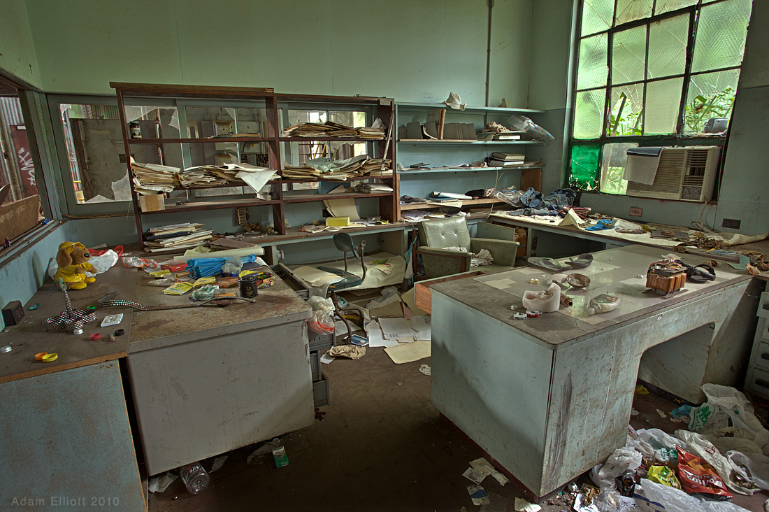
 This office looked like it was very recently occupied.

There were, what looked like child's drawings inside this first aid room.

Maree was sure the homeless people were going to come back and kill us, so she made me stop taking pictures long before we'd seen everything. A few striking things about the interior were that in the "husking and crushing" area there were still husks of sugar cane lying all over the machinery. There was also an interesting sub-floor area that had water flowing through canals in pitch black darkness, in some places making very strange noises. Below are some pictures Maree took.

There were a disturbing number of women's shoes on one floor of the building.

The sub level was very dark. Me in a flash.

The homeless camp.


Some parts were so overgrown they were nearly inaccessible. I can't believe the factory was just shut down in 2001.