Showing posts with label New Zealand. Show all posts

Friday, October 24, 2008

New Zealand: Last Days


During our Lost World tour i spoke to our guide about some other things in the area i had heard about. I had wanted to visit a small coastal town nearby but the road was closed, so he told me about a nice black sand beach down another nearby road. It was our last free afternoon in New Zealand, and although the Lost World had been a good workout we were motivated to do as much as possible.

This was a very cool waterfall, one of the best i've seen anywhere. You could go swimming if you wanted, but it created a large amount of cold misty wind.

A short distance from the Waitomo Caves area are numerous points of interest. There are several great forest hikes, and i wish i could have done one of them but our time was running out. We did stop at a place called Marokopa Falls. A five minute walk through the forest opens up to a fantastic view of an impressive wide cascading falls. It reminded me of Rescuers Down Under. We wanted to go swimming, but getting down proved the area to be more rugged than it looked from above. The official trail ended at the overlook so we had to carefully make our way down a steep, muddy, eternally wet path to the water. At the bottom the rocks were less inviting than i'd expected and the pools a bit less calm than i'd prefer. And i was no longer hot, so swimming was less important.


We left the pools and went to nearby Mangapohue Natural Bridge. The trail to the bridge was short and completely level, with a suspension bridge and an elevated pathway. It too, turned out to be really cool. The funny thing about it was that this bridge was in the middle of a small hill that could easily be walked around. The tiny little stream just chose to cut straight through it. There were two weird men there who got into a debate with me about whether or not that waterfall up the road was worth seeing. They hadn't seen it but claimed to have seen many waterfalls, and were extremely suspicious about my own claims that i'd seen a lot of waterfalls too, and that the one down the road was worth seeing. They almost seemed angry about it, which was just crazy. I think they were just tired.

The double bridge from below next to a viewing platform, with Maree in the upper window.


Switching positions, Maree is down on the lower platform and i'm standing on top of the lower bridge.


A grove of fern trees.

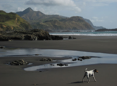
We decided to check out the beach. It took much longer than i'd guessed from looking at the map. Even though no one was on it, it took us forever because the road was extremely twisty. Eventually it opened up into farmland and deforested hillsides populated with cows and interesting limestone pillars. The road ended in a tiny community with no services right on the beach. As we got out of the car a little Jack Russel Terrier jumped out of his yard over a white picket fence and began to run next to us. He was super friendly, and i started to wonder if he jumps out of his yard and gives himself walks with whoever comes by walking along the shore.


The beach was very relaxing and entirely vacant except for a local who seemed to be meditating on a big rock. The waves were large and violent. We walked way down it until our little companion gave pause and started looking back at home. I got the sense we were taking him past his routine boundaries. He came along the whole time. He was an exceptional patrol dog, and took endless delight in not allowing seagulls to land anywhere.


Nobody around to the south or the north.

The tide began to come in, and local on the rock headed home. Just as we got back to the car and an old lady was furiously yelling her dogs name out her front door. I can't remember what is was anymore, but the doggie got that i'm in trouble look on his face, and jumping over the fence he went back inside to get scolded. I still had the feeling he did that all the time. The old lady was certainly unable to give him enough exercise.

I had a great time in New Zealand, and with some superficial modifications to my lifestyle, i think i could be happy living there. It's a great vacation destination, and not as expensive as i had imagined. Things have already changed drastically since then (way back in February), but at the time the most expensive element of the whole trip was the plane ticket. The rental car was reasonable, the hotels, which almost always had a kitchen (and included milk!?) came out on average to around $85 U.S.. Food was cheaper than it seemed at the time, once i got my credit card statements. Tours were not cheap but in most cases they were well done with exceptionally friendly (and likable) guides. If i personally were to go again i'd like to spend a week doing a multi-day cross country "Track" in Fjordlands and spend time visiting some of the nice northern beaches and forests. We came away having done almost everything we had planned on, but now that we've been there we know of many more things to be done.

Good memories.


Friday, October 10, 2008

The Lost World


Waitomo Caves absolutely rakes in the money. There are multiple tours going on in a cave at any one time, and likely that before you are done with your tour, another one has started behind you. The prices are much higher than average for cave tours. They had the most inflated prices for any activity we did. Waitomo Caves will purposely rip you off when you pay for the tour. Yes, that was phrased as a keyword search string. If they find out you are from a country with a stronger dollar they quickly ask you, when printing the receipt, if you want to pay one of two figures. One number, the NZ dollar is quite lower than the other, in our case, US dollar. What they are really doing though is making up their own exchange rate so that if you choose the NZ figure you end up paying more. I fell victim to the tactic because i was busy talking to Maree and reading some info and only glanced at the figures when they showed them to us. We were paying a substantial amount of money too, all of our tours at once.

That being said, Maree wanted to do the glowworms tour, and that was very cool. I wanted to do this tour called "The Lost World." We did this our second day. I was already infuriated because i knew this tour was going to be wildly photogenic but they wouldn't allow you to bring a camera. Instead, it was one of those lame things where they take the pictures with a cruddy camera and then try to sell them back to you at the end. Fortunately, we had another great guide, a Brit who'd done some hiking and climbing in the enviable Karakorum Range, so i instantly had a lot of questions for him.

Upon finally arriving at the location you are led through the woods to a deep black pit with a large natural window in the wall 60 to 100 feet down. Looking down through the window you see something that seems impossible, what appears to be a distant forest, thousands of feet away and bathed in light beams and mist. It truly looks like a portal to a lost world, and the effect is heightened by the limestone wall that frames it. Overgrown with all kinds of tropical vegetation, unusually thin stacked "masonry" (they call it pancaking) of grey stone eroded in to fins and almost-columns, it takes on the appearance of ancient Bali style ruins. Staring through that portal, you half expect to see pterodactyls flying by. Thus the name, "The Lost World." No pictures allowed of course, so i don't blame you if the description sounds ludicrous. After gawking for a short time you are dragged away from the impossible and made to go over somewhat dangerous trails that skirt some other pits. This unnecessary route obviously was designed to allow for practice of clipping in to guide ropes (we were in full caving gear) in a more controlled environment than what lay ahead.

In just a few minutes of meandering around a small hill we stepped onto metal cage viewing platform offering an explanation for what you saw only minutes earlier. This platform is cantilevered out over the lost world, which now revealed itself in an entirely new, more sensible but no less impressive perspective. We were standing over a huge rift in the ground formed by the collapse of the ceiling, long ago, of a huge underground hallway. What appeared earlier to be a forest canopy thousands of feet away was actually a thick covering of ferns and other moisture loving plants 328 feet down. The straight walls on either side were also covered in plants and extended for close to 100 yards in sunlight before continuing into a gigantic cave entrance. The overall impression was breathtaking, and it may be the closest i get to seeing the type of cave entrances that they have over in Borneo, or whatever it's called these days.

We were about to go down there. This was by far the biggest abseil i'd ever done, and it was also by far the most impressive location i'd ever been to abseil or go caving. Fortunately there were only 4 of us, me and Maree, and two young dentists from Scotland who were likable. So, i had nothing to complain about as far as that went. Unless otherwise stated, the following pictures are all stock pictures of models included on the cd they sold us later.


See? I told you it was otherworldly.


This is really us, not some stupid models.

The rappel took FOREVER. We were purposely going slow, and that was nice because the scenery was so stunning that it took a very long time to appreciate everything you were seeing. We were going so slow though, that i was getting bored by the time we were halfway down. It took at least twenty minutes, maybe thirty, and my entire right leg was completely numb by the time we hit bottom. Of course, i had to visually confirm that i hit bottom because my leg had no feeling in it. I could barely stand. In fact, that's all i could do for 5 minutes until the pins and needles finally returned to my leg.


In this picture you can see the cage platform at the top of the chasm.


And here the top part of the cavern entrance where the stream emerges. They didn't include pictures of the downstream entrance, which was actually more impressive.

While i was waiting to be able to walk again we noticed a big freshwater eel in the stream. It looked kinda like a black catfish in the front and an eel body behind. The stream was really shallow, probably due to drought, and the eel was so fat from people feeding it that it was almost trapped in the little eddy where it was hanging out.


Some stupid models in the way. You can see how depth perception is kind of screwy.

Down in the bottom things were no less impressive than up top. In fact it was downright thrilling. What appeared to be a flat floor from up high turned out to be a big hill we had to walk over as we made our way to the downstream entrance. There was lots of mist rolling around in shifting sunbeams and of course the temperature was great compared to the hot forest above. The terrain upon entering the cave was definitely rough and there was lots of hopping off muddy slick shelves onto huge uneven boulders that had fallen from above. One even had a small ladder on the side of it. I guess i looked adept at hopping across slick rocks because the guide assigned me to be assistant supervisor of something. He kept telling me to stop at places and watch everyone else go buy to make sure they were clipping and unclipping properly as he led to the next obstacle.


In this area we stopped to have lunch.


Maree is ready for Kung Fu action.

Just as we got to the point where there was virtually no light left from the gigantic entrance, we came to the point where we had to start making out way back out. I felt ripped off at this point because we had signed up for a half day tour, and we were just getting into the cave. I guess they count waiting for everyone to arrive, the van ride, dressing, orientation and walking through the woods all as part of the half day of caving. It was obvious though, that we couldn't go any deeper without getting into the stream and crawling through it under a pile of breakdown, and we did sign up for the "dry" tour, and since we were in the bottom, it wasn't likely to get any more impressive than what we had sees already, so i guess it wasn't the end of the world.

To get out, we had to somehow ascend 328 feet. The first 100 feet were via a long metal ladder that went through a hatch to an upper level. This ate up a lot of time too as each person had to go one at a time and i had to go last and pass up a big bag of extra caving gear that our guide had brought. Going last up the ladder was pretty neat. I turned off the headlamp so i could see all the glowworms on the underside of all the ledges i was climbing past. Before long though the guide thought i'd fallen off or something so i had to turn the light back on.


My super-long-ladder-climbing-muscles are all out of shape.

Above the ladder we were positioned on a dangerous ledge in a much narrower chasm that dropped 100 feet below us and and rose about 150 feet above us. It was definitely dark here and our lights could not penetrate the void either up or down. We traversed this area on ropes and a series of uncomfortable diagonal leaning ladders. You couldn't quite walk across them, nor could you really crawl or climb across them. It was just awkward. This area of the cave was much more entertaining and than i had expected and i was no longer pissed off.


Traversing part of the mid level chasm.

Eventually indirect light began to make an appearance from somewhere. Colors changed from beige to cold grey as calcite covered walls gave way to bleak limestone. Although we were still winding uphill traversing ledges and stepping across pits the floor transitioned from stone to leaves, mud and sticks. The thick odor of the forest descended upon us with warmth. Soon we would be back to reality. I began to go slower.

Tuesday, September 23, 2008

Waitmomo Caves

By Maree Shogren


Adam took me back to his hometown in Huntsville, Alabama for Thanksgiving a couple of years ago and introduced me to caves. I had never experienced such fear, intrigue, adrenalin and the will to live after getting in, and then out, of the cave on Green Mountain. I was so happy to be out of that cave and I was still alive! So now we look for caves to go in on our vacations or any other adrenalin inducing activities.


The north island of NZ is littered with more than 300 caves that people know of. There are probably a lot more that are yet to be discovered, but since most of the cave systems there are under privately owned farmland, there are only 7 caves that the public is allowed to go in. We were able to see 4 of them – 3 of them in one day. The cave tour companies lease the land from the farmers in order for people to experience them and charge an absurd price to do so.


The first cave we went in was Aranui Cave, which was discovered in 1910 by a Maori hunter who was chasing a wild boar in the jungle when it suddenly disappeared right in front of him. On closer inspection he found that the boar had escaped into the mouth of the cave. Since it was one of the first caves to be open to the public and back then they didn’t realize how badly humans and climate could damage the place, they mistakenly poured concrete throughout the cave to make the pathway less muddy, but in turn ruined the cave floor forever and tourists through the generations have snapped off many of the stalactites coming down from the ceilings. Of all the caves we went in this was probably the least impressive one. It did have an alabaster column in it that Adam said was rather rare and that he’d never seen one before. Oh! And we got to see a cave Weta which if you’ve seen the cave crickets in Alabama....these were 10 times the size as those and could very well knock someone out if it fell from the ceiling and landed on your head!


The second cave was Ruakuri Cave. Ruakuri, or ‘den of dogs’ as it translates into English, was first discovered by local Maori between 400 and 500 years ago. The name comes from the wild dogs that made their home in the cave entrance. They had started making the cave accessible to the public in the 1980’s, but then there was a big land dispute over who owned the caves. A farmer thought he should own the land above and below and the government thought they should own the land below, yadda, yadda...so the cave was left untouched for 18 years.


The farmer who snuck in the cave to plant this sign has darned good handwriting.

When they decided to go back and take a look at re-opening it, the whole cave system was full of chest-deep mud. This posed some problems, but they quickly decided to dig it out and very carefully. With new technology having been developed, they used an elaborate and scientific system to make this cave accessible, but also keep the integrity and climate of the cave intact. Just to go in, you have to go through an underground airlock 7 stories high. Since the Maori people believe that the living should not go underground (it’s where the dead live) they put a large greenstone at the bottom of the airlock, which is the entrance to the actual cave, with a constant flow of water dripping on it that you’re supposed to dip your fingers in to get cleansed before you enter the underworld. When you exit, you re-dip, just to ensure no bad spirits had followed you out. Then you walk down a Star Trek type of corridor complete with an airtight steel door at the end. Once inside they lock the door behind you and turn the lights on in the cave.

The first thing you notice is that the walkways are all suspended above the cave floor. The second thing you notice is a giant ‘cave curtain’. I had never seen one of these and I thought it was the coolest cave formation ever. It was probably about 10 feet tall with perfect ripples. It looked like it would make a nice drapery at home in my living room. So intricate and delicate and it took over 250,000 years for it to be made drop by little drop. This cave was awesome and our guide was a very knowledgeable geologist. He had helped dig the cave out in the beginning and loved his job. We also had our first glowworm sighting and we were able to actually see the worms up close and they weren’t worms at all! We went through a series of airlocks and saw quite a few rooms with stalagmites everywhere, one of which looked like a little gnome city. There were tons of fossils to ooooo and ahhhhh over as well.


Suspended walkways made for a unique experience, that allowed you to view the original cave floor.

The third cave we went in was the Waitomo Glowworm Cave. The tour starts out with a short walk into a giant room that apparently has fantastic acoustics. A bunch of different choirs from around the world (and even Kenny Rogers) have recorded songs in the room. Then we go into a dark grotto and get into an aluminum boat. Our guide stands on the bow and gingerly pulls us through the grotto using ropes attached to the cave walls. Everyone is really quiet and you can only here water dripping every now and then. There is no visible light down there and as your eyes slowly adjust to the darkness you can start to make out the shapes of the people around you and then…bam! The whole ceiling of the cave is covered in what looks like stars shining on a crystal clear night.

It was kind of weird to be able to see by the light of the glowworms. I mentioned earlier that they aren’t actually worms so I’ll explain that: Glowworms are actually fungus gnat larvae. They make a little hammock out of their silk webbing and attach themselves to the cave ceiling and then let out more webbing with dewy droplets on it to ensnare unknowing bugs. They have enzymes in their poop that make their butts glow. The unknowing bugs fly towards the ceiling thinking that it’s actually the sky and get caught and then eaten. Another interesting tidbit is that this is the only time in a fungus gnat’s life that they actually get to eat. Once they morph into gnats they no longer have a mouth or a stomach.


Gross Gloworm slime traps.

Adam and I had a great day of spelunking and were looking forward to our last cave adventure the following day. Squeezing through the entrance into the Green Mountain cave was the scariest thing I’ve ever done. Our next adventure is about to trump that.

Saturday, September 13, 2008

Queenstown and Beyond


Queenstown seemed like a pretty cool place. It's sits at one end of a huge windy lake. I'm not sure if the lake is a reservoir or natural. Unfortunately we were unable to take a look at Queenstown or do anything near it. We were exhausted by the time we got there. We ate, showered and went straight to bed. Up early the next day we had a 7 hour drive ahead of us. We had to catch a plane in Christchurch at 4:30 in the afternoon. It would would have been nice to see the town, but time was running out, and i also had wanted to go see Mt. Cook, the highest mountain in the country.


Really nice place to be a shepherd.

We'd gotten up early enough to take an hour and a half to make a detour that would take us to another dead end road, right in front of the mountain. Mt. Cook sits at the end of another lake, vivid blue like Peyto Lake in Canada or Cracker Lake in Montana. This one was definitely man made with canals splitting off to irrigate farmland. The mountain chain rises right up out of the plains, like the Tetons. The Remarkables, as they call them, are growing as fast as your fingernails, and that causes stress. We were told that the top 6o feet of Mt. Cook simply collapsed a few years back.


It was a pretty area, considerably different than the mountains farther south. We had no time to stay tough, and turned back around. After leaving the area we drove through some areas that were like the American West, particulary Idaho. We even passed some old gold mines that looked very western. Driving over just a few hills though and everything turned green and pastoral, and eventually flattened out.


Once again the airport experience was crazily relaxing and easy going. We arrived in Hamilton right on time, and finally got a decent rental car. A brand new 4 door automatic Camry. Man, it drove great compared to the other cars we'd had.


I'm pretty sure that this mountain was featured at the beginning of the second Lord of the Rings movie, filmed during winter.


The big lake that's next to Queenstown.

Saturday, August 30, 2008

Gertrude's Saddle


Even 3 hours away from Dunedin we had a difficult time finding a hotel room. The difficulty seemed to be standard on the South Island, which was kind of surprising since we never had any problems on the North Island. In Te Anau we used an i-station to find out that the only place that we could stay was basically a large hostel in a trailer campground. We had to get two different dormitory rooms, albeit next to each other and use a communal shower/bathroom area. It wasn't that bad, except that at about 2am some idiot who was probably smoking in their room managed to set off a fire alarm and the whole place had to be evacuated for ten minutes. I was glad i was wearing earplugs, because it was still incredibly loud.


We didn't get a great night of sleep but we were still excited to get back into Fjordlands. We had decided to do a hike with the terrible name of "Gertrude's Saddle." Normally if you asked me if i wanted to go to Gertrude's Saddle i would respond with a comment that only obliquely made sense, if at all, like "Do i look like Bertha?" I didn't know anything about the hike except where it started and that on the vague map it looked like it was less than 4 miles, maybe only a little more than two. In fact, i still don't know how long it is because every description of the hike lists it in terms of time (4 to 6 hours) instead of distance! According to more precise maps it looks closer to 2 miles in length, but is extremely steep after the first mile as it ascends close to 1,900 feet the second mile. Later i found out it's classified as "hard." It's fun though because it gets so steep you have to use these metal cables that are bolted into the rock so you don't fall back down.


The hike starts off near the Homer Tunnel, and the high alpine area, right at treeline, is home to the only alpine parrot in the world (at least that's what they tell me). The Kea was really cool, and there were lots of them hanging out tearing up the weather stripping of car windows and doors. They did it gleefully. And people thought it was cute and took pictures of the cute little guys destroying someones vehicle.


There was no way this Kea was letting anyone get near his awesome orange traffic cone.

Once again we walked through bizarre, interesting vegetation. It got hot fast. The dark rocks bake the valley floors like an oven. I appreciated the few patches of trees we passed through, and the initial shade. It was soon clear the hike was not going to be as easy as i thought. It seemed not to be maintained, even though it looked very popular. In no time at all the trail started doing annoying things like constantly splitting into numerous intermittent paths that wasted energy as the wrong ones were often chosen.

As i mentioned earlier, the first mile was slowly but steadily uphill, until the back of the valley was reached. Then it rose sharply up the side of the mountain, typically following a water drainage up to a high valley. The drainage area was similar to the Sierra Nevadas. Water slipped down wide expanses of smooth, bare stone. Things began to get large scale, and it was supremely nice day. I drew on the photos so you can see what i mean.


This monolithic cliff, athough it doesn't look it in this sucky picture, is 1,000 feet high and a mile wide.


Eventually the smooth rock faces became so steep as to be dangerous. At that point metal cables made an appearance. They were useful, particularly for going downhill. I imagine if it was icy it would be necessary to clip in to avoid dying.


We got up to a place called Black Lake where Maree called it quits. Her back was still bothering her, and carrying her pack up to that point had really irritated it. So i continued on up more smooth slabs with cables and then across a boulder field, until the trail suddenly ended. "Sudden" because the trail stops without warning at the edge of an enormous cliff.


Wow. I was not expecting this view. I'd been staring at walls of rock all morning, always going up hill, and then the top of the hill was actually the end of the mountain. I could finally see the tops of many of the nearby peaks. The exhibited a weird uniformity. The forest canopy was 3,000 feet below me (i was as high as El Capitan, in California).


A hiker stands near the precipice. The grass in the foreground on the right side of the image is actually the very edge of the cliff. I was leaning back against a rock wall to avoid falling off while i took the picture. It was scary. Depth perception and perspective are screwy looking because those streams below are literally straight down below. The wide angle of view is making it more exaggerated.

People coming down kept saying it was a spectacular view. They were right. The view was down a valley that connected to the main valley we had driven down the day before. That is, unless i was looking at the main valley and yesterday we had been in a side valley. I could see all the way to the ocean in Milford Sound. Thick tundra and grass continued to the very edge of the cliff, which was one of the reasons you couldn't see it coming until you were there.


Some of the new type of tundra i was walking on up on the saddle.


I walked up one side of the saddle to take a VR above this lake. At this point, looking back at the opposite side of the valley we had come from, the mountain tops looked within reach, if only there was a way to get to them.

I ate some lunch, explored the area to take a VR and started running back. More running, yes, because i knew i had taken some time and Maree would be tired of waiting for me. I got back down to Black Lake without blowing out my knees but Maree was gone, so i kept going without stopping. On the way down i performed this cool maneuver to pass a group of about 6 Germans on some steep crumbly, partially wet mountainside. I guess that was a mistake. When i was about 30 feet below them, they got all excited at started yelling gibberish. I thought WTF? and looked up at them, just in time to see softball size rock whizzing down at my head. I was not in a place where i could simply jump out of the way. It landed on top of my foot and it hurt pretty bad. So, think twice before you pass a bunch of fast hiking Germans, or they might try to kill you.


Maree was no longer waiting here. In this shot you can see one of the cables, right above the letter "I" at the beginning of this sentence. Again, this is a very wide angle shot so you can't tell how steep it is.


Some of the neat plants on the valley floor.


After this point we entered patches of trees pictured here. They provided cool shade and momentary refuge from the blazing bright sun. The road is over there at the base of the mountain, a dark line in the greener colored trees.


We got back to the car with just enough time to drive for three hours so we could get to Queenstown right at sunset. It was a great day. I didn't know till i was writing this blog that Queenstown, although a three hour drive, is only 35 miles in a straight line from the road that goes through Fiordlands!